The Sea Is Editing Britain’s Hillforts — And the Race Is to Read Them Before It Finishes
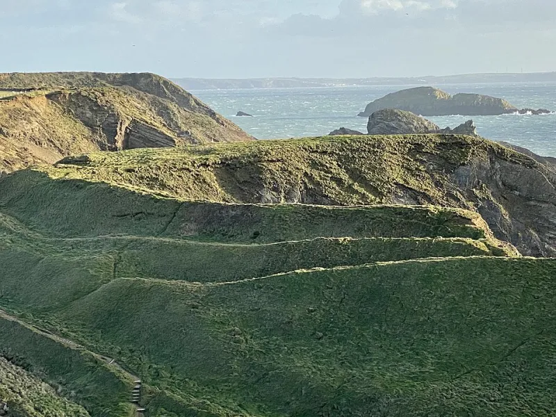
Photo: Alan Hughes, CC BY-SA 2.0, via Wikimedia Commons
Stand on a coastal path in Cornwall, Wales or East Lothian and you may be walking across the edge of an Iron Age hillfort without realising it. The ramparts are often grassed over, the ditches shallow, the whole thing folded into the shape of the land. Then you look at the sea below and notice that a chunk of the cliff has gone. That is the scene playing out around Britain’s coastline: ancient defended sites, many of them scheduled monuments, being nibbled, undercut and occasionally dropped into the waves after a winter storm.
This is not a new story. Coasts have always changed. But the pace of loss has made coastal hillforts a priority for archaeologists, not because they can save every metre of bank and ditch, but because they can record what is there before it disappears. The result is a strange kind of race: drones humming over headlands, volunteers photographing exposed sections, and heritage bodies working out which sites can be defended and which must be documented and let go.
What is a hillfort, actually?
The word hillfort is a modern label, and it is a bit of a trap. It makes people picture a grim military installation, all warriors and burning gates. In reality, the sites we call hillforts were built and used across the Iron Age, roughly from 800 BC to the Roman conquest, and they come in a bewildering variety. Some sat on dramatic hills. Others were promontory forts on coastal headlands, defended by banks and ditches across the landward side while cliffs did the rest. The Rumps in Cornwall and Dinas Dinlle in Gwynedd are good examples of coastal sites where the sea is now a major factor in their future.
Many hillforts were settlements, with roundhouses, storage pits, hearths and workshops. Some were places where people gathered, traded, feasted or marked out status. Their banks and ditches may have said as much about community and belonging as about defence. That does not mean violence never happened — Maiden Castle in Dorset famously shows signs of a violent episode — but the default image of every hillfort as a war fortress is misleading. Archaeologists have spent decades chipping away at that assumption, and coastal sites are part of the rethink.
Why the sea is the problem
Coastal erosion is a natural process, but it is not happening in a vacuum. Storms, sea-level change, rainfall and coastal management all affect how quickly cliffs fail. When a soft cliff gives way, it can take archaeological layers with it: floors, hearths, pottery, animal bone, slag from metalworking, the lot. A scheduled monument is not a force field. Scheduling recognises a site’s importance; it does not stop the sea.
Heritage at Risk registers across Britain have long flagged coastal and eroded sites. The options are rarely simple. Hard defences can be expensive and can shift the problem along the coast. Excavation is costly, and sometimes the most responsible approach is not to dig everything but to record what is exposed, sample carefully and make the results available. Archaeologists call this preservation by record. It can sound like giving up, but it is often the most honest response to a coastline that will not stay still.
The drone’s-eye view
This is where the recording race gets interesting. Drones and photogrammetry can capture a headland in three dimensions, creating a model that can be measured, compared and revisited long after the cliff has moved. LiDAR can strip away scrub and show the bones of the landscape. Volunteers can walk transects, photograph exposed sections and help map changes after storms. Local archaeology societies, museums and historic environment records all play a part in making sure the information does not stay in one notebook.
It is not magic. A drone survey still needs ground truthing, and a photogrammetry model is only as good as the points someone has recorded on the ground. But the combination of fast digital survey and local knowledge is powerful. A site that might once have been visited once a decade can now be monitored after every serious storm. The record becomes a living thing, updated as the coast changes.
What are we learning?
Coastal hillforts are not just crumbling ramparts. Erosion can expose sections that have been sealed for centuries, revealing how people built, ate, worked and traded. A fallen block of cliff may show a sequence of occupation; a newly exposed ditch may hold pottery or animal bone; a hearth may survive just long enough to be sampled. Each exposure is a window that opens and closes.
The coastal setting matters too. These were places connected to the sea, to routes along the coast and to networks of trade and movement. Some may have controlled harbours or landing places. Others may have been seasonal or ceremonial. The old idea of a hillfort as an isolated fortress on a hill misses the point that many were part of busy, connected landscapes. The sea was not just a threat; it was a road.
The uncomfortable question
Do we save coastal hillforts or record them? In practice, it is usually both, but not everywhere. Some sites can be managed with vegetation, drainage or carefully placed defences. Others are on a trajectory that no amount of engineering will stop without damaging the very thing we value. In those cases, the priority is to make sure the archive is excellent: survey, photographs, samples, reports, and public access to the results.
That is why community volunteers matter. If you walk a coastal path and see a new exposure — a scatter of pottery, a section of bank that has slumped, a hearth newly visible in the cliff — do not dig it. Contact the local historic environment record or archaeology service. A photograph with a location can be genuinely useful. The race is not to bag a find; it is to understand a place before the sea edits it out.
Britain’s hillforts are often presented as dramatic ruins with a simple story. The reality is messier, more interesting and more human. They were homes, gathering places, statements in the landscape and, sometimes, defensible refuges. The sea is now editing that story in real time. The best response is not to pretend we can stop the tide, but to read carefully while we still can.